Introduction
GPSMAP 1222 Keyed Networking Chartplotter – No Sonar
12-inch Chartplotter Is All-in-1 Solution
- 12-inch color display with keypad interface and multifunction control knob
- High-sensitivity internal 10 Hz GPS and GLONASS receiver
- Fully network capable for Garmin Marine Network and NMEA 2000plus NMEA 0183 support
- Supports optional BlueChart g2 Vision HD charts for Auto Guidance and other premium navigation features
GPSMAP 1222 is designed for cruisers, sailors and sailing racers who need the advanced all-in-1 solution provided by our 10-inch keyed chartplotter. Features a large, bright screen coupled with a quick and easy-to-use keypad interface with user-programmable keys and a multifunction control knob.
Complete Network Sharing
Garmin Marine Network support allows sharing of sonar, maps, user data, dome or open-array radar, IP cameras and Panoptix sonar among multiple units. Includes NMEA 2000 network connectivity and NMEA 0183 support for autopilots, digital switching, weather, FUSION-Link, VHF, AIS and other sensors.
Built-in ANT Connectivity
Enjoy built-in ANT wireless connectivity directly to quatix marine watch, Garmin Nautix in-view display, gWind Wireless 2 transducer, GNX Wind marine instrument and wireless remote controls.
The Ultimate Connected Boating App
Built in Wi-Fi gives you access to the free all-in-one ActiveCaptain app, so you can manage your marine experience from nearly anywhere. It creates a simple yet powerful connection between your compatible mobile device and your Garmin chartplotter, charts, maps and the boating community. Wherever you are, you’ll have unlimited access to your cartography, the ability to purchase new maps and charts and access to the Garmin Quickdraw Contours Community. Stay connected with smart notifications on your chartplotter screen. You can also plan a trip or prefish a lake, and ActiveCaptain will automatically sync with your chartplotter. Even get notifications for software updates, and decide when to download them on your device.
Heading, Position Refreshed 10 Times per Second
Fast, responsive built-in 10 Hz GPS and GLONASS receiver refreshes your position and heading 10 times each second to make your movement on the screen more fluid. It makes dropping up to 5,000 accurate waypoints and finding your way back to them quick and easy.
Upgrade to Our Best Maps on the Water
Two SD card slots provide expandable memory for accessory map purchases, such as LakeV HD, LakeV HD Ultra, BlueChart g2 HD or BlueChart g2 Vision HD, which adds Garmin patented Auto Guidance and other great features.
Built-in SailAssist Features
To help you gain a wind-maximizing competitive edge, your chartplotter features a pre-race guidance page that shows your virtual starting line along with data fields showing laylines, time to burn before the start and a race timer that can be synchronized across all your networked Garmin GPS products. In addition, other supported sailing features include an enhanced wind rose, heading and course-over-ground lines, set and drift, true and apparent wind data and more.
GPX Waypoints Transfer
If you have waypoints, tracks or frequently used routes stored on another manufacturer’s GPS product or on a Garmin handheld device it’s easy to transfer those items to your new Garmin chartplotter via industry-standard GPX software formatting.
In The Box
- GPSMAP 1222 chartplotter
- Power/data cable
- NMEA 2000 T-connector
- NMEA 2000 drop cable (2 m)
- Bail mount kit with knobs
- Flush mount kit with gasket
- Protective cover
- Trim piece snap covers
- Documentation
Connections
- Garmin Marine Network Ports: 2
- NMEA 2000 Port: 1
- NMEA 0183 Input Ports: 1
- NMEA 0183 Output Ports: 1
- Video Input Ports: 1 BNC
- Video Output Ports: No
- Wireless Connectivity: Yes
Auto Guidance is for planning purposes only and does not replace safe navigation operations.
iPhone and iPad are trademarks of Apple Inc., registered in the U.S. and other countries. App Store is a service mark of Apple Inc. Wi-Fi is a registered trademark of the Wi-Fi Alliance.
Garmin GPSMAP 1222 12-inch Chartplotter Is All-in-1 Solution
Model: 010-01741-00
UPC: 753759168339
- 12-inch color display with keypad interface and multifunction control knob
- High-sensitivity internal 10 Hz GPS and GLONASS receiver
- Fully network capable for Garmin Marine Network and NMEA 2000 plus NMEA 0183 support
- Supports optional BlueChart g2 Vision HD charts for Auto Guidance and other premium navigation features
GPSMAP 1222 is designed for cruisers, sailors and sailing racers who need the advanced all-in-1 solution provided by our 10-inch keyed chartplotter. Features a large, bright screen coupled with a quick and easy-to-use keypad interface with user-programmable keys and a multifunction control knob.
Garmin Marine Network support allows sharing of sonar, maps, user data, dome or open-array radar, IP cameras and Panoptix sonar among multiple units. Includes NMEA 2000 network connectivity and NMEA 0183 support for autopilots, digital switching, weather, FUSION-Link, VHF, AIS and other sensors.
Enjoy built-in Wi-Fi connectivity for BlueChart Mobile 2.0 and Garmin Helm apps. Garmin Helm allows you to view and control your compatible chartplotter from a compatible smartphone or tablet while providing enhanced situational awareness for the mariner. With BlueChart Mobile, a free app downloaded from the App Store, you can get reliable weather information while you plan marine routes on your iPad or iPhone then wirelessly transfer them to your boats compatible networked Garmin chartplotter. You can even stream and control a VIRB action camera from the chartplotter.
Enjoy built-in ANT wireless connectivity directly to quatix marine watch, Garmin Nautix in-view display, gWind Wireless 2 transducer, GNX Wind marine instrument and wireless remote controls.
Fast, responsive built-in 10 Hz GPS and GLONASS receiver refreshes your position and heading 10 times each second to make your movement on the screen more fluid. It makes dropping up to 5,000 accurate waypoints and finding your way back to them quick and easy.
Two SD card slots provide expandable memory for accessory map purchases, such as LakeV HD, LakeV HD Ultra, BlueChart g2 HD or BlueChart g2 Vision HD, which adds Garmin patented Auto Guidance and other great features.
To help you gain a wind-maximizing competitive edge, your chartplotter features a pre-race guidance page that shows your virtual starting line along with data fields showing laylines, time to burn before the start and a race timer that can be synchronized across all your networked Garmin GPS products. In addition, other supported sailing features include an enhanced wind rose, heading and course-over-ground lines, set and drift, true and apparent wind data and more.
If you have waypoints, tracks or frequently used routes stored on another manufacturers GPS product or on a Garmin handheld device its easy to transfer those items to your new Garmin chartplotter via industry-standard GPX software formatting.
1Auto Guidance is for planning purposes only and does not replace safe navigation operations.
Specifications
| Performance and Physical |
| Dimensions |
14.1″ x 8.9″ x 2.7″ (35.8 x 22.6 x 6.9 cm) |
| Display size |
10.3″ x 6.4″ (26.2 x 16.3 cm) |
| Display resolution |
1280 x 800 |
| Display type |
WXGA display |
| Weight |
5.2 lbs |
| Water rating |
IPX7 |
| Antenna |
Internal or external over NMEA 2000 |
| NMEA 2000 compatible |
Yes |
| NMEA 0183 compatible |
Yes |
| SiriusXM Weather & Radio compatible |
Yes |
| Power consumption |
Max power usage at 10 Vdc: 34.8 W
Typical current draw at 12 Vdc: 2.2 A
Max current draw at 12 Vdc: 2.9 A |
| Mounting options |
Bail or flush |
| Maps and Memory |
| Preloaded maps |
None |
| Accepts data card |
2 SD cards |
| Waypoints |
5,000 |
| Routes |
100 |
| Track log |
50,000 points; 50 saved tracks |
| Outdoor Recreation Features |
| Tide tables |
Yes |
| Chartplotter Features |
| Garmin Radar compatible |
Yes |
| Garmin Sonar compatible |
Yes (with external black box, sold separately) |
| Garmin SmartMode compatible (customizable monitor presets) |
Yes |
| Supports AIS (tracks target ships position) |
Yes |
| Supports DSC (displays position data from DSC-capable VHF radio) |
Yes |
| Garmin Meteor Audio System compatible |
Yes |
| Supports FUSION-Link compatible radios |
Yes |
| GSD Black Box sonar support |
Yes |
| GCV Black Box sonar support |
Yes |
| ActiveCaptain compatible |
Yes |
| Garmin Helm compatible |
Yes |
| GRID (Garmin Remote Input Device) compatible |
Yes |
| Wireless remote compatible |
Yes |
| Sonar Features & Specifications |
| CHIRP sonar technology |
Yes (with external black box, sold separately) |
| ClearV |
Yes (with external black box, sold separately) |
| SideV |
Yes (with external black box, sold separately) |
| Connections |
| NMEA 2000 compatible |
Yes |
| NMEA 0183 input ports |
1 |
| NMEA 0183 output ports |
1 |
| Video input ports |
1 BNC |
| Video output ports |
None |
| Wireless connectivity |
Yes |
What’s in the Box:
- GPSMAP 1222 chartplotter
- Power/data cable
- NMEA 2000 T-connector
- NMEA 2000 drop cable (2 m)
- Bail mount kit with knobs
- Flush mount kit with gasket
- Protective cover
- Trim piece snap covers
- Documentation
GARMIN Gpsmap 1222 is brand new. GARMIN Gpsmap 1222 GPSMAP 1022 is specially designed for cruisers, sailors and sailors who need the advanced all-in-one solution provided by our 10-inch keyed chartplotter. It has a large and bright screen, as well as a fast and easy-to-use keyboard interface, user-programmable keys and multi-function control knobs.
!!!!—-
PRODUCT ID: 63442
SKU: NVN-63442
CSKU: CWR-63442
REWRITE: 74553-garmin-gpsmap-1222-keyed-networking-chartplotter
MPN: 010-01741-00
UPC: 753759168339
ASIN:
WSKU: GAR0100174100
SSKU:
KSKU:
GSKU:
MSKU:
LSKU: 322-0100174100
NAME: Garmin GPSMAP 1222 Keyed Networking Chartplotter – No Sonar
NAME_EX:
PTITLE: Garmin GPSMAP 1222 Keyed Networking Chartplotter – No Sonar
TYPE: Marine Navigation & Instruments | GPS – Chartplotters
VENDOR: Garmin
Google Category:
Amazon Category:
Amazon Title:
Google Title:
Amazon Category:
Gtags:
GSpecs:
 FREE SHIPPING ON ORDERS OVER $30
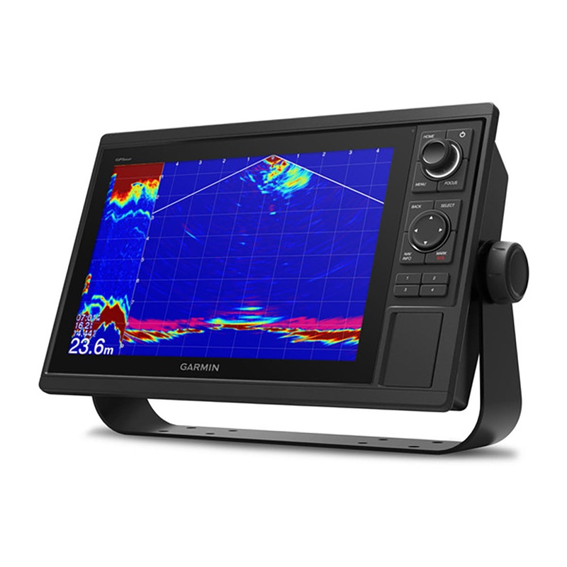 Sale!
Sale! 
Reviews
There are no reviews yet.